Almost Nothing Left at First & Denny!
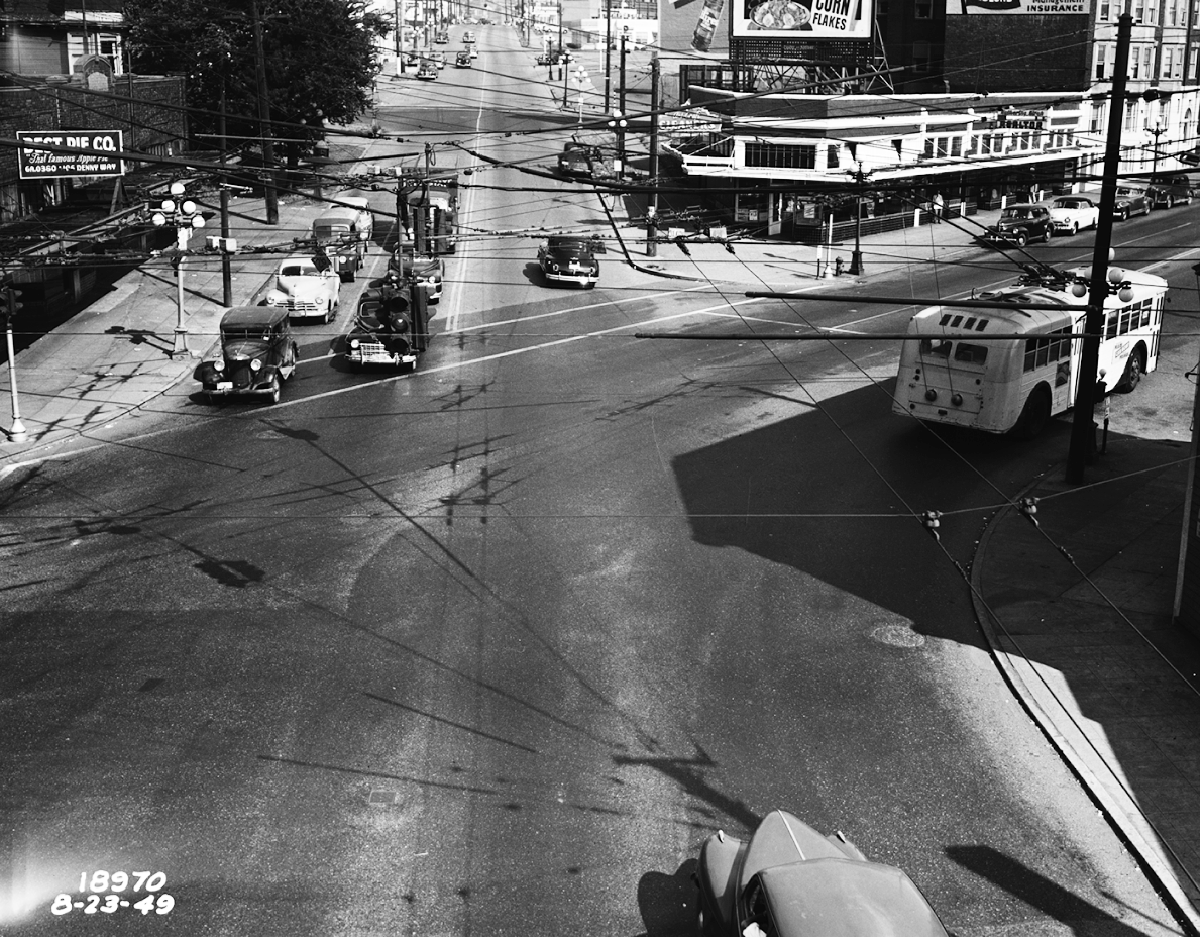
Looking east up the hill at Denny Way and First Avenue. Photo: Seattle Municipal Archives.
This odd-shaped intersection separating Queen Anne’s Uptown from Belltown is uniquely historic. It doesn’t add much to local history that the line demarcating Queen Anne as studied by the Queen Anne Historical Society runs along the middle of Denny Way. As you might suspect, though, our line of demarcation is not a random choice. In fact, it separates William Bell’s 1853 land claim from David Denny’s, and provides a neat reminder of the day in February 1853 when David’s older brother Arthur and his brother-in-law Carson Boren jockeyed with Doc Maynard for the site of Seattle’s downtown and argued about how to lay out the city.
Doc wanted the street grid to follow standard north-south east-west lines. He got his way south of Yesler Way and everywhere in King County -- except in the future downtown. There, Arthur Denny and Boren insisted that their plats (the middle and southern ones) follow the coastline of Elliott Bay. Their fellow Alki pioneer, William Bell, followed their lead in the northernmost downtown plat, shifting his claim at Stewart Street to follow the shoreline as it moved a bit to the west. Doc got his grid, but the three coastline advocates got downtown.
Denny Way is also an odd name for a busy street. But for reasons unknown, city founders used ‘way’ for the three streets marking the edge the downtown claims; Yesler Way and Broadway are the other two. David, for whom Denny Way is named, disregarded his brother’s idea and laid out his Queen Anne streets to line up with the cardinal points of the compass.
The view here is to the east up the hill from the intersection with First Avenue North on the north side and First Avenue on the south. The intersection in our 1949 picture reflects the awkward and sometimes cumbersome meeting of the two grids in much the same way as all the avenues hit Denny going up the hill and east to Broadway.
As we approach the end of 2016 and contemplate the looming redevelopment of Uptown, it is astounding, some might say alarming, that all the buildings except the Center View Apartments, with the bay windows at First and Warren, will have been replaced by the end of the coming year. Even the small flat-iron building on the southeast corner has been replaced in the last couple of months by a multi-story apartment dwelling. Sadly, having the famous apple pie proclaimed on their sign hasn’t helped the Best Pie Company’s building on the facing corner survive. Hosting Tini Bigs Lounge today, it is like the last man standing and will be demolished soon.
In a surprising number of ways, this image leads us to thoughts about the commercial history of Queen Anne and Uptown from Seattle’s founding in 1853 to their nearly complete reconstruction in this first quarter of the 21st century. From First and Denny you can see the edge of David and Louisa Denny’s farm and their patch of sweetbriar roses, the First United Methodist Church, at least four almost brand-new multi-family buildings, and in the distance the site of the 1962 Century 21 World’s Fair and Seattle Center. Even the jumble of overhead cables and the bus turning south along its former route on First Avenue remind us of the evolution of our street railways as they morphed in 1941 into electric trolleys just eight years before this picture was taken.